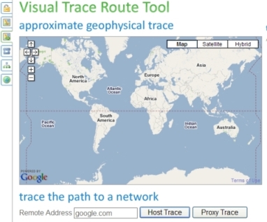
Looking for a tool to visualize the trip or the path your data packets take to reach a specific destination? Try yougetsignal, a free visual trace route tool. Powered by Google Map, this visual trace route tool identifies the IP addresses of each hop along the way to the specified destination network address and displays the estimated geophysical location in the Google Map. By visualizing and understanding the data packets travel, you can know how many hops the data packet requires from your computer to reach an internet host and how long each hop takes. It’s pretty cool and interesting.
 Tip and Trick
- How To Download HBO Shows On iPhone, iPad Through Apple TV App
- Windows 10 Insider Preview Build 19025 (20H1) for PC Official Available for Insiders in Fast Ring – Here’s What’s News, Fixes, and Enhancement Changelog
- Kaspersky Total Security 2020 Free Download With License Serial Key
- Steganos Privacy Suite 19 Free Download With Genuine License Key
- Zemana AntiMalware Premium Free Download For Limited Time